You have 3 free guides left 😟
Unlock your guides4.4 Defining Political Boundaries
8 min read•june 18, 2024
Amanda DoAmaral
Riya Patel
Amanda DoAmaral
Riya Patel
Defining Political Boundaries
are lines or areas that are used to demarcate the territory of a political entity, such as a country or state. These boundaries are used to define the areas over which a particular government or political entity has jurisdiction and the areas within which it can exercise its authority.
Political boundaries can be established through a variety of means, including treaties, agreements, and negotiations between governments or other political actors. In some cases, political boundaries are based on natural features such as rivers, mountains, or other geographical landmarks, while in other cases they may be arbitrary lines drawn on a map.
Political boundaries are often associated with ideas of sovereignty, territoriality, and jurisdiction, and they play a central role in the organization and functioning of political systems. They can also be sources of conflict, as different groups or individuals may have competing claims to the same territory or may disagree about the appropriate boundaries of a particular area.
Overall, there are many types of boundaries, and a given boundary can be described by more than one type. Hang in there, and try to form mental connections to help yourself understand them (rather than just memorizing).
Types of Boundaries
Defined boundaries are established by a legal document.
Delimited boundaries are drawn on a map.
Demarcated boundaries are identified by physical objects, like walls, signs, and fences.
Any boundary is also determined by either natural or geometric lines.
Natural boundaries are boundaries that are based on natural features such as rivers, mountains, or deserts. These boundaries are often used to mark the edges of a political entity's territory because they are easy to identify and difficult to change.
Here are a few examples of :
- The is a natural boundary that was built to protect China from invaders. It stretches for more than 4,000 miles and follows the natural topography of the landscape, including mountains and rivers.
- The are a natural boundary that separates China, India, and Nepal. These towering mountain ranges are some of the highest in the world and form a natural barrier between these countries.
- The is a natural boundary that separates the United States and Mexico. This river, which runs for nearly 2,000 miles, marks the border between these two countries and is an important natural feature in the region.
- The is a natural boundary that separates the countries of North Africa. This vast desert is one of the driest and hottest places on earth, and it forms a natural barrier between the countries of the region. In a political context, a geometric boundary can refer to a line or plane that divides one political entity (such as a country, state, or city) from another.
Here are a few examples of in politics:
- The border between the United States and Canada is a geometric boundary that separates the two countries.
- The line that divides the states of New York and New Jersey is a geometric boundary that separates the two states.
- The border between two cities or municipalities can be thought of as a geometric boundary that divides the two jurisdictions.
- The boundary between two neighborhoods within a city could be considered a geometric boundary.
- The line that divides an electoral district or voting precinct is also a geometric boundary in a political context.
Whereas political boundaries are usually clear, also exist more fluidly.
Cultural boundaries are boundaries that are based on cultural differences, such as language, religion, or ethnicity. These boundaries can be used to mark the edges of a political entity's territory, but they are often more fluid and less fixed than other types of boundaries.
Here are a few examples:
- The , which is centered around competing claims to land that is considered holy by both Jewish and Palestinian cultures.
- The in Spain, which is driven in part by Catalan cultural identity and the desire for greater autonomy.
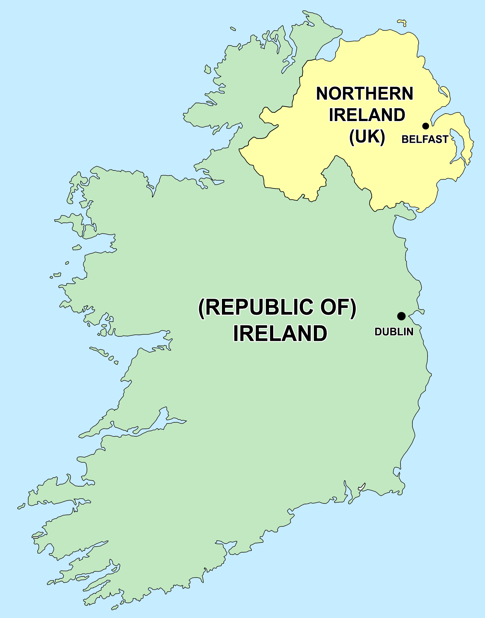
- The conflict in Northern Ireland, which has been influenced by the cultural divide between Protestant and Catholic communities.
- The debate over immigration policy in the United States, which has often been fueled by concerns about preserving American cultural values and traditions.
- The debate over the wearing of burqas and other Islamic veils in European countries, which has been driven in part by concerns about the integration of Muslim immigrants into secular Western cultures.
Economic boundaries are boundaries that are based on economic factors such as trade routes, resource deposits, or economic development. These boundaries can be used to mark the edges of a political entity's territory, but they are often more dynamic and subject to change than other types of boundaries.
Here are a few examples:
- , such as tariffs or quotas, that are imposed by one country on imported goods from another country. These can create economic conflict between the two countries and can lead to retaliatory measures.
- , which are imposed by one country or group of countries on another country as a way to punish or deter certain behavior. Economic sanctions can have significant impacts on the economy of the targeted country.
- The , which is a political and economic union of 27 European countries. The EU has removed many between member countries, allowing for the free movement of goods, services, and people.
- The , which is a trade agreement between the United States, Canada, and Mexico. NAFTA has removed many economic boundaries between these countries, leading to increased trade and economic cooperation.
- The , which is a trade agreement between several countries in the Pacific region, including the United States, Japan, and Australia. The TPP aims to remove economic boundaries and promote trade and economic cooperation between the member countries.
🎥 Watch: AP HUG - Boundaries and Disputes
Boundaries Over Time
Boundaries are also classified based on when they were created. Antecedent boundaries are drawn before the cultural landscape emerged and before a large population was present, like the border between the US and Canada.
Other examples of include:
- Physical features such as mountains, rivers, and coastlines, which can act as natural barriers that make it difficult for people to move or communicate with one another.
- Climates and ecosystems, which can influence the types of crops that can be grown and the types of animals that can be raised in a particular area. These factors can shape the way that people live and trade with one another.
- Geological features such as oil deposits or minerals, which can influence the economic development of a region and create conflicts over resources.
- Cultural and linguistic differences, which can arise from the long-term isolation of different groups of people from one another due to antecedent boundaries.
Subsequent/ethnographic boundaries are formed based on religious, ethnic, linguistic, and economic differences between groups of people. For example, the boundary between Northern Ireland and the Republic of Ireland was drawn long after people were settled and reflected the religious differences between the two places.
Relic boundaries are boundaries that used to exist and can still be detected on the landscape, like the Great Wall of China and the . In Berlin, the old location of the wall is marked throughout the city with commemorative bricks, but there are other signs of where the wall used to be. West Berlin had more economic resources than East Berlin and this created an economic boundary that outlasted the wall.
Consequent boundaries occur where boundary lines coincide with cultural boundaries. Take Utah for example. The concentration of Mormons in Utah creates a cultural boundary when it comes to religious buildings and norms. Mormons do not drink, so the under presence of bars is immediately obvious within the political boundaries of the state.
Here are a few examples of :
- The division of Germany into East and West after World War II. The boundary between the two countries was created as a result of the Allied victory and the subsequent occupation of Germany by the Soviet Union and other Western powers.
- The division of the Indian subcontinent into India and Pakistan in 1947. The boundary was created as a result of the partition of India by the British government, which resulted in the creation of two independent countries.
- The division of Yugoslavia into several independent countries in the 1990s. The boundary between these countries was created as a result of the breakup of Yugoslavia and the declaration of independence by various constituent republics.
- The border between the Republic of Ireland and Northern Ireland, which was established as a result of the . The boundary has been a source of conflict and tension between the two sides.
- The border between the United States and Canada, which was established as a result of negotiations between the two countries in the late 18th and early 19th centuries. The boundary has been relatively stable and peaceful, and has facilitated trade and economic cooperation between the two countries.
Superimposed boundaries are forced onto people by outside powers, like when Africa was divided by European powers. Another example of this was the experience of Native Americans in the United States. The political boundaries of the states were superimposed on the Indigenous communities, despite having nothing to do with creating them.
Militarized boundaries are guarded and hard to pass through, like the borders of North Korea. The 38th parallel is almost impossible to cross without military or elite clearance.
Here are a few examples of :
- The , which is a strip of land that runs across the Korean Peninsula and separates North and South Korea. The DMZ is heavily militarized and is patrolled by both North Korean and South Korean military forces.
- The border between the United States and Mexico, which has been heavily militarized in recent years due to concerns about illegal immigration and drug trafficking. The border is patrolled by U.S. Border Patrol agents and is fortified with walls and other barriers.
- The border between India and Pakistan, which has been the site of ongoing conflict for decades. The border is heavily militarized and is patrolled by both Indian and Pakistani military forces.
- The , which is a wall that was built by Israel in the West Bank in order to separate Israeli and Palestinian territories. The wall is heavily guarded and has been the subject of controversy and protests.
- The border between North and South Vietnam, which was heavily militarized during the Vietnam War. The border was guarded by both North Vietnamese and South Vietnamese military forces and was the site of numerous battles and skirmishes.
Open boundaries are where crossing can be done freely. The European Union is an example of where citizens of any EU country can freely cross into and even work in other EU countries. Someone might live in the Netherlands, but work in Antwerp in Belgium while their kids attend school in Germany, all within less than an hour of each other.
🎥 Watch: AP HUG - Boundaries and Governance